

 |
| View of the Saint Croix River on the Minnesota Side |
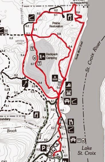
In our decision to backpack the Superior Hiking Trail we needed to find some local trails that offered challenging climbs, descents, as well as some scenery to make it more fun. After some extensive googling we landed on Afton. It's only a 30 minute drive from the Twin Cities and the reviews all suggested greatness. We printed out their handy and well labeled map, tied up our boots, and hit the trail.
We were blown away.
This park has everything an outdoor enthusiast could want. The reviews did zero justice to the huge vistas over the St. Croix River that stretch to the other side looking into the rolling hills of Wisconsin. Each bend in the trail offered a new feature extending deep into the woods or popping out into an open prairie with sweeping views.
Some main highlights of the park include:
- 20 miles of hiking trails (all laid and marked on map)
- 18 miles of maintained snowshoeing trails in the winter months
- 28 backpacking campsites
- 4 camper cabins
- 2 picnic grounds with 50 tables
- 4 miles of bike trails
- 5 miles of horseback riding trails
- 2 rustic group campsites
- 1 canoe campsite
- Large visitor center
- Small store at check-in office
The trails are expertly maintained and offer difficulty from a morning stroll on a flat trail that parallels the river to high cliff climbs and low valley descents from ridge lines.
Some of the hiking trail features include:
- Multiple river views from high vistas
- 8 - 10 hard hill (river bluff) climbs
- Beautiful creek that follows 1.5 miles of trail
- Picnic tables and benches along the trail at great view points
- Well labeled and clearly marked maps with mileage markers and "you are here" dots at all intersections
- Different loops that offer trail from low valleys to open prairie
- Multiple parking lots for convenient day and overnight parking
- Bathrooms along the trail (nicest and cleanest ones We've ever seen in a park)
- Drinking water station near the campsites
- Free maps in the check-in office
In this post we will highlight different sections of the trail and give mile by mile descriptions of what you can see and experience. Each section seems to transport you into different terrain and gives you an all over experience of what Minnesota has to offer.
Grading Scale of Difficulty
Easy - Low to no hills
Medium - Some hills mostly rolling
Medium to Hard --- Many hills up and down some steep or scrambling - -
Difficult - Hard climbs and descents - extremely tiring or using full exertion
Download the Summer, Winter, and Camping Maps HERE
Parking
When entering the park you will come to the Park Rangers Office. There is a $5 fee to enter a Minnesota State Park or you can pay a one time fee of $25 for an annual pass that gets you into any state park in Minnesota. Remember - Any veteran with any percentage of disability receives free day pass to Minnesota State Parks.
Follow the road 2 miles through some winding hills until you reach the parking lots on your right hand side. The first lot is for campers and buses only. You can use any of the other 3 parking lots. The visitors center will also be on your right hand side.
Check out the visitors center for helpful tips, free activity packets for kids (receive a patch at the main office when completed), drinking fountains, and bathrooms.
Pick which direction you want to hike and hit the trail!
 |
| Route to Parking Lot |
Deer Valley Loop
Difficulty: Medium to Hard
Total Distance: 3 miles
Start: from second parking lot; cross to the west side away from the Visitors Center. Trail head is nestled in between deep forest and a picnic table. Start by heading south on the trail walking through a wide trail with high trees. Continue through a small section of prairie. After .5 miles the trail turns right.
Follow through a deep and steep assent into the lower valley. Trail is less wide with thick forest and undergrowth around. Continue here for the next .5 miles.
The next 1.8 miles will follow many ups and downs inside deep forest climbing through a dried up creek bed (in late summer) and the trail winds sharply through undergrowth. This section is perfect for training for hiking or endurance running. This trail is also labeled as a snowshoe trail in the winter months.
A long winded ridge climb will get you back out of the valley as you follow the last .2 miles north to the point at which you turned. Stay north to return to the parking lot.
Keep your eyes pealed on this section. It's named Deer Valley for a reason!

 |
| Deer Valley Loop |
Difficulty: Easy with middle section of Medium
Total Distance: 4.5 Miles
Start: Walk east towards the Visitors Center and turn left to go down stairs or right to end your hike going up them. I will be giving directions assuming you go left.
Trail leads on a paved path for the first .5 miles through a picnic area and wraps around a second picnic area with views of the river. Follow signs to stair case that will lead into lower valley *warning there are a lot of stairs* at the bottom of the stairs go to the right. You'll be on a paved path again which will come to a 4 way intersection. Turn sharply to the right to be on the trail.
This 1.6 mile section is great for day walkers, going for a stroll, or catching your breath on a long hike. You'll be walking on a perfectly flat, straight, and wide gravel trail that curves right along the Saint Croix river. This section has flawless views and a staircase where you can go straight down to the river and walk out onto sandbar. The path will take a sharp turn to the right and you will start a slow assent into the bluffs.
We rated medium because of the one large hill. It's steady but high. At the end of this section you will come out of the woods and continue straight through .7 miles of prairie. The next mile goes through mixed forest including a lot of pine which offers some great views of nature. The last .7 miles will come to a paved trail that winds through the butterfly gardens and prairie land. There is a grassy trail 10 feet to the right that you can follow if you are training for off road terrain.
This section will end in front of the Visitors Center. This is the easiest section you can take without having to climb any severely steep bluffs.

 |
| Winding Paths Through Greenery |
Leg Day Loop
Difficulty: Difficult
Total Distance: 5.5 Miles
Start: By stretching because this one will make the calves burn. If you're looking for training on endurance, high cliff climbs, or enjoy pain then try out this loop! It was great training for hiking high bluffs that are similar to the North Shore.
Start heading north through the picnic area on the paved trail. Head down the long stair case and continue straight on the gravel trail. You'll pass through the river campsites and by restrooms on your left. Continue .4 more miles until the road forks and turn sharply to the left.
Your first section will be .6 miles long starting with a short sharp hill leveling off to a long slow climb to the top of the ridge. Continue for the next .4 miles through open prairie and a little over hang forest. At the four way split turn quickly to the left to take the next .8 miles back down into the lower valley. If you have trouble with your knees or balance I would suggest having a trekking pole or walking stick for this section.
The bluff starts gradually descending past some campsites showing the diversity of the terrain with some great lookouts over the river then veers abruptly downward on a 3 foot wide natural trail covered in loose rock and washouts. If you are practicing with full pack weight remember to lean so that you don't fall over from your extra weight on your back.
Take your time going down the hill because you will have to go right back up at the next section. At the bottom you will cross a footbridge going over a stream that has a few good spots to fill up with water. You will climb another short hill and end on the same trail you took previously.
Head south on this short .2 mile section and turn right at the intersection to get back on the trail. The sign for this trail is large and is labeled "Campsites" in yellow lettering. The next .7 miles will be entirely uphill. The trail offers 4 different places with benches to rest with great views of the river. The bluff is fairly consistent in steepness as you climb on the gravel and dirt path. It will level out slightly as you start to pass the backpacking sites. You will pass a water station with clean drinking water on you left.
You will end at the same intersection where you started your large descent. Turn left and take the .1 miles through a gravel trail and turn left at the next 4 way intersection. The first .4 miles is on a wide path with gravel and dirt offering expansive views into the underbrush of the forest. Your second .4 miles will start your descent back into the valley following a dried up creek bed. This is not as steep as your first descent but watch your footing for loose rock.
At the bottom of the trail turn right at the intersection to head back on the same trail you came in on. You will now be at the bottom of the stairs and will have to hike back up to get through the picnic areas to the Visitors Center.
Remember to stretch again because this one will hurt the next day! We tied this section into our 15 mile hike to prepare for the Superior Hiking Trail. We'd have to say it sure did it's job!
 |
| Section of the creek - great water source! |
Day Hike Plus Prairie Loop
Difficulty: Medium to Hard
Total Distance: 9 Miles
Start: Head north in the same direction as the river loop. You will pass picnic tables and will tread on a paved trail until you come to a large stair case that descends into the valley. At the bottom of the stairs turn right and continue straight on this path. This trail is gravel and you will pass bathrooms and campsites as well as a beautiful creek and views of the river. Continue on this for .8 miles until you come to the end of the road and take a sharp turn to the left.
Here you will begin hiking into the woods. You will encounter a steep hill right away that tappers off to flat up on top of the ridge. You're in for one more climb through the open story pine and birch trees until you come out into a field. A slow hill will bring you to the very top of the ridge with beautiful views of the valley and river.
Turn right onto the next trail and follow for .3 miles. At the end of this section you pass a pristine bathroom and shelter. Turn right at the fork and you will enter the first prairie loop. This extends for the next mile so make sure you have water. There's no tree cover but you walk through beautiful fields with high views of the surrounding areas.
After the prairie loop you will descend quickly through a deep forest into the bottom of a ridge line. Here you will find the trail head for the Trout Brooke Loop. Either way you go you will encounter a very steep climb up and then back down. At the fork if you turn left you will go up a staircase and down a long drawn out descent and if you turn right you will hike up the long descent then drop quickly down the stairs back into the valley. This section follows a clean and beautiful stream with foot bridges and great chances for pictures.
*Note* for anyone test running a backpacking hike this stream is perfect for trying out your water purifier. The water itself is perfectly clean but there are low spots by the creek with rapids to fill up your water bottle. We tried in late summer and the stream was cold enough to produce condensation on our water bottle.
After the loop you will climb .3 miles up a very steep and high ridge. Hold onto your hats because this one is hard. *Lean on tree for 10 minutes to catch your breath* After the ridge you will come out of the forest to continue the prairie loop. The next 1.5 miles will be out of the tree cover and in the sun. You can opt to skip the last .7 miles of prairie by taking the .1 trail.
Turn right at the trail split and continue into the forest for .5 miles. You will have a slow and gradual climb along a ridge line. Look down both sides and appreciate how narrow the bluff is! You will start to descend back into the lower valley. There is a nice bench right before the trail slopes down.
Keep straight at the fork in the road and continue for .7 miles. You will be hiking up a slow hill on a gravel road that crosses in front of the ski hills from Afton Alps. At the top of the hill you will switch back to catch the last .3 miles to the parking lot. This section is overhang forest with glimpses of the ski resort.
This route is challenging and enjoyable affording many views of the valley, prairie, and deep forest. It's a perfect route if you're training for a long hike. Fill up your water from the Visitors Center and take a break!


 |
| Bubbling and cold stream - perfect for trying out water purifier on the Trout Brook Loop |
There are plenty of areas for camping with families and this park is full of hikers, backpackers, family groups, campers, runners, and guided tours. Dogs are allowed in the park but must be leashed.
This park overall is beautiful, well maintained, family friendly, and a short drive from the Twin Cities.
Go enjoy it while summer lasts!
Go breathe the wild air
#CreektoPeak


Nice review and write-up. Thanks.
ReplyDeleteWe're missing the summer months now! Looking forward to warm spring days and getting back on the trail.
ReplyDeleteThank you for the comment!